

Geospatial Tools for Environment, natural resources monitoring and Urban Modelling
Earth and Space Sciences
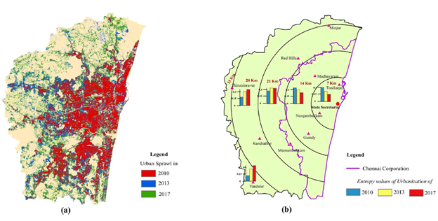
1. Urban Growth Models (UGMs) play a vital role in sustainable development of a city to predict the future urbanization based on the present scenario. Deep learning based Cellular Automata (DB-CA) techniques proved to predict the urban growth of Chennai Metropolitan Area (CMA) of 2017 as 524.14 km2 with higher accuracy (kappa co-efficient: 0.73) when compared to Neural Network based-CA model which predicted only 502.42 km2 as urban (kappa co-efficient: 0.71), while the observed urban cover of CMA in 2017 was 572.11 km2. Results of directional analysis reveal that Chennai Corporation and its periphery experience congested urbanization whereas areas away from the Corporation boundary follow dispersed type of urban growth in 2017
Figure 1. Urban Sprawl and Entropy of the study region. (a) Urban sprawl of the observed urbanization of CMA in 2010, 2013 and 2017; (b)Entropy values of urbanization of the study region for five distance based buffer zones from the State Secretariat
2. Analysing the spatio temporal dynamics of Banana crop using and Multi Criteria Decision Making analysis and use of machine learning algorithms to map the agricultural and horticultural crops including Banana which is a kind of rare study on horticultural crops.
 |
Figure (i) Banana intensification 2016, 2017 and 2018, (ii) Slope map, (iii) Rainfall map of 2017
 |
Figure (i) Distance from drainage, (ii) Soil map, (iii) Land Suitability map for banana
3. Measurements and exploration of texture and mineral composition of beach sediments was carried out in collaboration with National Institute for Interdisciplinary Science and Technology, Ministry of Science and Technology to understand the nature of mineral deposits
4. National level modelling of PM 2.5 was carried out using Aerosol Optical Depth data (Deep Blue Dark Target) of MODIS using Mixed Effects Modelling and could achieve R2 value of 0.75 with RMSE of 20.09 μg/m3. The daily variation of PM2.5 was modeled using its relation with satellite-derived AOD values for the first time for the entire country. Inclusion of road density improves the accuracy levels than other parameters such as extent of agriculture, forest, and open space. The study also had shown the Spatial interpolation integrated MEM can be used to fill the gaps in the estimation of PM2.5 because of the non-availability of AOD for the particular time and location.
 |
 |
Figure: Estimated PM2.5 concentrations (μg/m3) Minimum (left) and Maximum (right) for Indian subcontinent using SpatioTemporal Mixed Effects Model (STMEM) including open spaces, forest cover, agricultural areas, road density, and temperature.
- Ref: Aarthi, A.D. and Gnanappazham, L. (2019) Comparison of Urban Growth Modeling Using Deep Belief and Neural Network Based Cellular Automata Model—A Case Study of Chennai Metropolitan Area, Tamil Nadu, India. Journal of Geographic Information System, 11, 1-16. https://doi.org/10.4236/jgis.2019.111001
Ref: a) Manjunath CB, Gnanappazham L, Vijayakumar RM, Kavino M, Jagadeeswaran R and Ramsubramoniam S (2019) Machine learning classifiers on sentinel-2 satellite image for the classification of banana (Musa Sp.) plantations of Theni district, Tamil
b) Vijayakumar, R.M., L. Gnanappazham, C.B. Manjunath, M. Kavino, R. Jagadeeswaran, S. Ramsubramoniam and Jeyakumar, P. (2019) Evaluating the Variables for Banana (Musa Sp.) Crop Intensification in Theni District, Southern India using Multi-Criteria based GIS Analysis. Int. J. Curr. Microbiol. App. Sci. 8(11): 407-423. doi: https://doi.org/10.20546/ijcmas.2019.811.051Ref: RG Rejith, M Sundararajan, L Gnanappazham, VJ Loveson (2020) Satellite-based spectral mapping (ASTER and landsat data) of mineralogical signatures of beach sediments: a precursor insight, Geocarto International, 1-24.
Ref: SLK Unnithan, L Gnanappazham (2020) Spatiotemporal mixed effects modeling for the estimation of PM2.5 from MODIS AOD over the Indian subcontinent. GIScience & Remote Sensing 57 (2), 159-173